
Texty.org.ua 数据新闻负责人叶夫赫尼娅·德罗兹多娃,正在介绍她所在媒体如何运用卫星图像报道乌克兰战争。图:Suzanne Lee / AltStudio,为GIJN拍摄
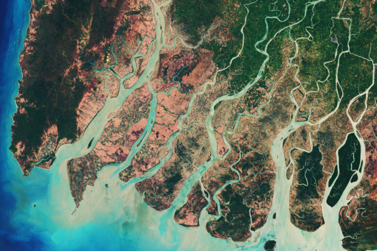
When journalists cannot cross borders, pass checkpoints, or enter bombed neighborhoods, reporting does not stop, but often shifts to methods that do not require physical access. In such conditions, satellite imagery, once limited to use by governments and intelligence agencies, has become a routine reporting tool for documenting civilian harm and investigating potential war crimes.
That shift shaped the “Using Satellite Imagery to Investigate War Crimes” session at the 14th Global Investigative Journalism Conference (GIJC25), where reporters explained how remote sensing, open source verification, and visual forensics are now central to covering conflicts that are inaccessible or actively hostile to journalists. At GIJC25, speakers stressed that satellite data is most powerful when used alongside traditional reporting, helping journalists establish timelines, verify claims, and document patterns of destruction when physical access is denied.
Moderated by Hoda Osman, executive editor at the Arab Reporters for Investigative Journalism (ARIJ), the panel brought together reporters and data journalists who have used satellite imagery to investigate conflicts ranging from Gaza to Ukraine.
From Pixels to Proof
Manisha Ganguly, investigative correspondent and visual forensics lead at the Guardian, situated satellite imagery within the broader field of open source intelligence. Open source investigations, she said, draw on multiple streams of data, including social media intelligence, geospatial intelligence, and traditional human reporting.
“Geospatial intelligence is something that is fairly new for journalists,” Ganguly said, noting that nation states historically controlled satellites. The rise of commercial satellite imagery has changed the reporting landscape, giving journalists an aerial view of conflicts that were previously difficult or impossible to access.
Ganguly traced the origins of modern open source war investigations to the Syrian civil war, when the spread of smartphones and internet access generated unprecedented volumes of visual evidence. At the time, many satellite tools were free, creating what she described as a “democratizing moment” for journalism.
“That landscape has changed,” Ganguly said. While some providers made imagery freely available during conflicts in Ukraine and Gaza, she said access remains uneven and targeted. (For tips on how to acquire free satellite imagery for investigations, check out this GIJN webinar.)
Despite those constraints, satellite imagery has become essential in documenting civilian harm. Ganguly described how radar mapping and optical imagery can be used to detect changes over time, like tracking destroyed buildings and bulldozed land, even when journalists cannot enter an area.
“War does have rules,” she said, pointing to international law frameworks such as the Geneva Conventions and the Rome Statute of the International Criminal Court. Satellite imagery, she added, helps establish what was destroyed, where, and when — foundational questions in war crimes investigations.
Mapping Destruction in Ukraine
The use of satellite imagery at scale was central to investigations in Ukraine, according to Yevheniia Drozdova, head of the data journalism section at Texty — official name Texty.org.ua. Since Russia’s full-scale invasion in 2022, she said, satellite images have become a routine reporting tool.
“What you need to know about satellite images is that they are more than just pictures,” Drozdova said. Satellites collect data across different parts of the light spectrum, allowing journalists to detect changes that are not visible to the naked eye.
She described how radar satellite data, which can see through clouds, was used to detect Russian military camps near Ukraine’s border in late 2021. While individual vehicles were not visible, patterns in the data revealed sudden changes consistent with military buildup.
“We couldn’t see these camps with our eyes,” she said. “But if such patterns appear suddenly and were not there before, you can be pretty sure that these are military vehicles.”
Drozdova also described how radar imagery was used to track sea traffic between Iran and Russia after 2022, as military cooperation between the two countries deepened. By aggregating images over time, journalists could identify increases or decreases in traffic without counting individual ships.
Another tool she highlighted was nighttime illumination data or nighttime lights, which can indicate economic activity or population displacement. In Ukraine, declining nighttime lights marked towns and cities that had been heavily bombed or abandoned.
“All the red spots are cities, towns, villages that don’t exist anymore,” she said, referring to maps showing lost illumination.
High-resolution imagery allowed for more detailed investigations, including documenting damaged buildings and reconstructing Russian defensive lines. In some cases, Textyused machine learning to identify destruction patterns across large territories.
“When you have thousands of destroyed buildings, you can’t just do it with your eyes,” Drozdova said.
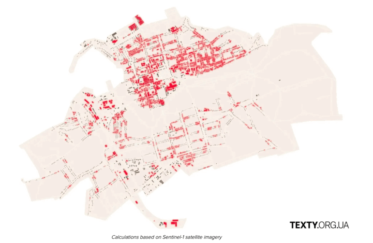
In 2024, Texty used satellite imagery from Sentinel to document the widespread destruction of the village of Vovchansk by Russian forces (areas in red). Image: Screenshot, Texty
Documenting Alleged War Crimes in Gaza
Ganguly also described in detail the investigations in Gaza, where satellite imagery was combined with videos, medical records, and witness testimony to document alleged war crimes.
In one investigation, she said, satellite imagery was used to document the destruction of civilian infrastructure, including hospitals, schools, mosques, and agricultural land across three neighborhoods in northern Gaza.
“There was no apparent military reason for destroying this infrastructure,” Ganguly said, adding that the scale of destruction raised questions of proportionality under international law.
She said she documented the destruction of more than 250 residential buildings, 17 schools and universities, 16 mosques, three hospitals, and 150 agricultural greenhouses in those areas. The findings were later used by legal groups challenging arms sales.
Satellite imagery was also used to analyze attacks near hospitals. Ganguly described how radar mapping showed hospitals surrounded by craters and tanks, restricting access for ambulances and civilians.
“Attacking hospitals and medical staff is a war crime,” she said.
In another investigation, Ganguly examined shootings near aid distribution sites in Gaza. Using satellite imagery, videos, medical records, and interviews, she said she documented patterns of gunshot wounds that matched the timing and locations of aid deliveries.
“If this crowd of people could be seen from space, then the plausible deniability does not hold,” she said, referring to satellite images showing large groups of civilians near aid sites.
She also described documenting the killing of Palestinian journalist Bilal Jadallah, using satellite imagery and shrapnel analysis to reconstruct the attack on a route designated as safe.
“Bilal was killed by Israeli tank fire on a route that was marked safe,” Ganguly said.
Collaboration, Limits, and Responsibility
Polina Uzhvak, a journalist with IStories Media, emphasized that satellite imagery is most effective when combined with collaboration. Many newsrooms, she said, lack in-house technical expertise.
“We are a small media team,” Uzhvak said. “None of my colleagues are remote sensing specialists.”
To overcome that, IStories partnered with technical analysts to assess destruction in Mariupol, Bakhmut, and Severodonetsk. Using AI-based models and radar data, the team mapped damage across entire cities.
But satellite imagery has limits, she cautioned. Some destruction is invisible from above, particularly interior damage.
“Satellites look at the earth’s surface from above,” she said. “We can detect only those damages that are visible from above.”
Still, the method allows journalists to document large areas systematically — something traditional reporting cannot always do during war.
Uzhvak urged journalists to clearly define roles when collaborating with technical teams and to communicate their editorial goals early.
“We, as journalists, know our stories better than anyone,” she said.
Watch the full GIJC25 panel video below.
 Hanan Zaffar is a media practitioner, multimedia storyteller, and documentary filmmaker based in India. His work primarily focuses on South Asian politics, minorities, human rights, and the environment. His reporting has appeared in TIME Magazine, the Guardian, VICE, Al Jazeera, Business Insider, and other places. He has also had reporting stints in Southeast Asia, Africa, and Europe, and is the UN Foundation’s 2025 Polio Press Fellow.
GIJN Reporter’s Guide to Investigating War Crimes

How to Acquire Free Satellite Imagery for Your Investigations
Journalists’ Guide to Using AI and Satellite Imagery for Storytelling
Resources for Finding and Using Satellite Images

Why Any Reporter Can Now Source Free, Quality Satellite Images of Almost Anywhere on Earth
Tips for Using Satellite Imagery in Forensic Investigations, from Amnesty International’s Evidence Lab

Reporter’s Tipsheet for Acquiring Free Satellite Images

Remotely Investigating Russia’s Devastation of Mariupol

This work is licensed under a Creative Commons Attribution-NoDerivatives 4.0 International License
Republish our articles for free, online or in print, under a Creative Commons license.
Republish this article
This work is licensed under a Creative Commons Attribution-NoDerivatives 4.0 International License
Read Next
Reporting Tools & Tips
Why Any Reporter Can Now Source Free, Quality Satellite Images of Almost Anywhere on Earth
At a recent GIJN webinar, three experts explained how reporters can get regular, free access to high-quality satellite images covering almost anywhere on Earth.
Methodology News & Analysis
Tips for Using Satellite Imagery in Forensic Investigations, from Amnesty International’s Evidence Lab
When the Myanmar military started conducting airstrikes on its citizens, researchers at Amnesty International began a forensic investigation into the supply chain, using satellite imagery to find out how aviation fuel was getting into the country, and who was supplying it.
Tipsheet Investigative Techniques Reporting Tools & Tips
Reporter’s Tipsheet for Acquiring Free Satellite Images
There is a treasure trove of compelling visual evidence out there that is going unused by many watchdog journalists. Here’s how to find it.
Methodology
Remotely Investigating Russia’s Devastation of Mariupol
In March 2022, Human Rights Watch embarked on what would become an almost two year-long investigation into the Russian siege of Mariupol. Here, we explain our methodology.