Image: NASA Image and Video Library / Creative Commons
Satellite Companies Restrict Journalists’ Access to Images from the Iran War
Read this article in

Embracing Failure: The Importance of Learning from Your Mistakes in Open Source Reporting

Essential Reading: A Cheat Sheet for Open Source Digital Security Options
AI Journalism Lessons from a 150-Year-Old Argentinian Newspaper
How Environmental Journalists Can Use NASA’s New Landsat 9 Satellite
[Editor’s Note: This story has been updated as of April 6, 2026 to reflect that Planet Labs is now indefinitely withholding all of its satellite imagery of the Middle East from the public, at the request of the US government. Also, numerous news organizations have reported that a US military investigation has concluded the US was responsible for the Tomahawk strike on the school in Minab, Iran.]
In the days after a missile slammed into a girls elementary school in Minab, Iran, on Feb. 28, killing about 175 people, most of them children, open source investigation teams at news organizations used satellite images and videos to probe the source of the attack. Now, two of the largest providers of satellite imagery, Planet Labs and Vantor, are limiting access to images from across the Middle East.
On Saturday, Planet shut off all images from the region at the request of the US government — exactly the kind of images that journalists used to conclude that a Tomahawk missile fired by the U.S. was probably responsible for the deadly attack on the school. Earlier, Planet had restricted access to images in their archives for two weeks. The new policy amounts to a total block. Vantor will also limit who’s able to use images from the conflict.
Going forward, Planet will apply a two-week hold on all images from the region in the companies’ image archives — exactly the kind of images that journalists used to conclude that a Tomahawk missile fired by the US was probably responsible for the deadly attack on the school. Vantor will also limit who’s able to use images from the conflict.
President Trump has denied US involvement in the missile attack, while Secretary of Defense Pete Hegseth said it is still under investigation, adding: “Open source is not the place to determine what did or did not happen.”
Both Planet Labs and Vantor have extensive contracts with the federal government, including the military and intelligence agencies. In a statement, Planet said the move was taken “after consulting with experts inside and outside of government… in an effort to limit any uncontrolled distribution of the images that might result in their unintentional access and use as tactical leverage by adversarial actors.”
Vantor denied that the restrictions were made at the request of the government, adding in a statement that “during times of geopolitical conflict, Vantor may implement enhanced access controls to prevent the misuse of sensitive geospatial intelligence.”
High Stakes for Investigative Journalism
Investigative teams using open source methods at The New York Times, Bellingcat, The Washington Post, the BBC, and other news organizations used satellite images to show that a precision weapon had hit the school in Minab and videos to identify the type of missile. It’s just the most recent example of how analyzing satellite images and videos has revolutionized investigative journalism, from documenting war crimes in Ukraine to contradicting the official story of the shooting by federal agents of Alex Pretti in Minneapolis.
The quality of Planet’s images are particularly useful in investigations like the missile strike. “Planet’s high res imagery allowed us to analyze multiple strikes on the [adjacent] military base and the primary school,” explained Merlyn Thomas of the BBC’s Verify investigative team in a post on Instagram.
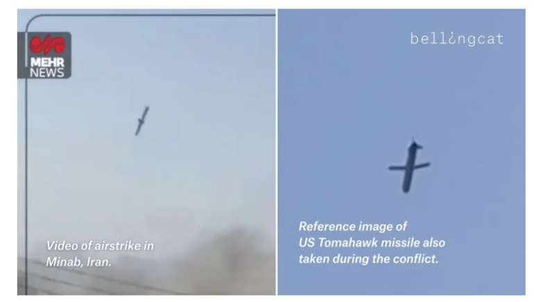
Bellingcat compared a video (left) from the Feb. 28 airstrike in Minab to footage of a Tomahawk missile flying over Iran’s capital, Tehran, from earlier in the conflict. Image: Screenshot, Bellingcat
“In cases like the Minab missile attack, timely satellite imagery is essential for verifying damage, locating impacts, and cross-checking eyewitness content and other open-source evidence,” said Carlos Gonzalez, head of research for Bellingcat. “A two-week delay slows the verification process and makes it more difficult to establish facts while events are still developing.”
“The main effect of the delay is on the level of certainty we can achieve quickly,” he continued. “Without near-real-time images, our findings require more careful qualification until visual confirmation becomes possible.”
Gonzalez says Bellingcat will continue to innovate around obstacles. “Even when the most recent imagery is unavailable, older satellite data can still support geolocation, terrain mapping, infrastructure analysis, and contextualization of ground-level videos or photos…. When access to one source is limited, we adapt by combining alternative sources to corroborate events and strengthen the evidentiary record.”
Editor’s Note: This post was originally published by Storybench and is reprinted here with permission. It was updated after publication with a clarification from Planet Labs on their image sharing policy going forward.
Dan Zedek is a professor of practice at the Northeastern University School of Journalism and faculty advisor of Storybench.
Embracing Failure: The Importance of Learning from Your Mistakes in Open Source Reporting
Essential Reading: A Cheat Sheet for Open Source Digital Security Options
AI Journalism Lessons from a 150-Year-Old Argentinian Newspaper
How Environmental Journalists Can Use NASA’s New Landsat 9 Satellite

This work is licensed under a Creative Commons Attribution-NoDerivatives 4.0 International License
Republish our articles for free, online or in print, under a Creative Commons license.
Republish this article
This work is licensed under a Creative Commons Attribution-NoDerivatives 4.0 International License
Read Next

Resource Video
How to Acquire Free Satellite Imagery for Your Investigations
Satellite imagery has become a game-changer for investigative journalism, offering powerful tools to uncover hidden stories.
Investigative Techniques Reporting Tools & Tips
Journalists’ Guide to Using AI and Satellite Imagery for Storytelling
Satellite imagery provides information that can enhance the ability to write compelling narratives about the state of our planet, cutting across multiple beats. But such a tool tends to be complex and out of the reach for many journalists, so this guide offers a process that reporters interested in covering the climate crisis can use for story projects.
News & Analysis
How BBC Experts Confirmed Hundreds Killed in Iran’s Protest Crackdown Despite an Internet Blackout
Marina Adami speaks to Shayan Sardarizadeh, a senior journalist at BBC Verify, about how his team is reporting on Iran in the midst of an internet blackout.

Editor's Picks News & Analysis Reporting Tools & Tips
GIJN’s Top Investigative Tools of 2024
In 2024, new and innovative digital tools provided leads and evidence for accountability stories on every continent.