Tips for Using Satellite Imagery in Forensic Investigations, from Amnesty International’s Evidence Lab
Read this article in

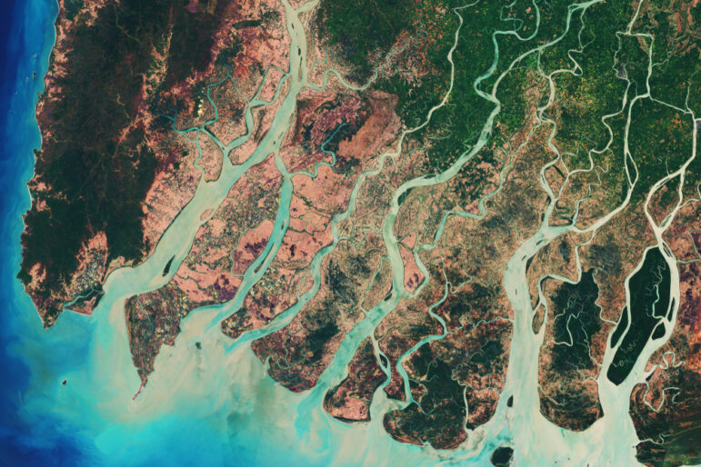
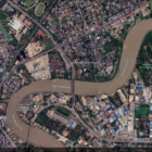
A satellite image showing the delta of the Irrawady, a river that flows from north to south through Myanmar. Investigators can drill down into satellite images to see particular buildings, roads, and even cars and people. Image: Shutterstock
Green roofs on a cluster of buildings and a large, circular entrance, big enough for a lorry to turn around. These were the minute visual clues that investigators were looking for while trawling through reams of satellite images from Myanmar after the February 2021 military coup.
Identifying the locations of critical fuel depots could help researchers at Amnesty International (AI), a human rights organization, explain how aviation fuel, linked to deadly airstrikes in Myanmar, reached the country and was supplied to its military.
Since seizing power two years ago, Myanmar’s military has increasingly used its air force to carry out strikes. Bombs have been dropped on a camp for displaced people, on those trying to escape the violence in the country, in Kayah state, and in numerous civilian areas, causing loss of life, injury, and mass displacement.
AI’s Deadly Cargo investigation into the supply chain of Myanmar’s military, in collaboration with activist group Justice for Myanmar, found that the junta is relying on aviation fuel that is “supplied, imported, handled, stored, and distributed by a number of companies, both foreign and domestic.” The impact of being linked to a regime accused of war crimes was immediate: One of the companies named in the investigation announced plans to leave Myanmar just 10 days after the report was published.
The investigation used a variety of sources, including leaked company documents, public records, interviews with military defectors, airstrike survivors’ testimony, and, crucially, satellite imagery. The latter helped the team to identify vital links in the supply chain, from the location of storage depots and the routes of fuel deliveries by sea to jet activity on airstrips in Myanmar and damage caused by airstrikes.
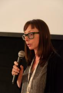
Amnesty International’s Micah Farfour, presenting at IJF23. Image: Creative Commons, Riccardo Urli
At the 2023 International Journalism Festival in Perugia, Italy, Micah Farfour, a special advisor for remote sensing in AI’s Evidence Lab, walked attendees through the use of satellite imagery analysis in this investigation and shared tools and tips regularly used in her work.
“Satellite imagery is becoming more and more available to everyone,” said Farfour, adding that Amnesty employs it to plan investigations and guide pre-reporting. “We will use satellite imagery to see areas where there’s a lot of activity or where villages have been burned, or to see where a lot of IDPs [internally displaced persons] or refugees are located and we will plan our investigations accordingly,” she explained.
Satellite imagery was also used in another investigation into Myanmar published by the think tank Chatham House, to interrogate claims that a Chinese intelligence facility is being built on Myanmar’s Coco Islands in the Bay of Bengal.
Why Use Satellite Imagery for Investigations
When investigating or reporting on a crisis situation, such as the military coup in Myanmar or the current conflict in Sudan, satellite imagery can get you access to hard-to-reach areas within a few days — or even 24 hours — owing to the number of satellites in orbit.
That allows investigative journalists to look at a sequence of events, for example before and after an airstrike, sometimes days or minutes after it has happened. “This is much easier for research purposes and documenting human rights abuses,” said Farfour.
There are also security and safety benefits, Farfour said: “Maybe you don’t want to send a journalist to the field. We are often very protective of our researchers. They can still get some visual elements from the ground by looking at satellite imagery.”
Satellite imagery has proved to be a “fairly quick, fairly cost-effective way” to corroborate testimony too, as the power of a picture when publishing the results of an investigation is undeniable. She added: “No one’s convinced by words, but if you show them a picture [they are far more likely to be convinced].”
Farfour encouraged reporters to think about where satellite imagery can add value to investigations, but also conversely, to consider scenarios where it won’t aid reporting or for practical reasons just won’t work.
Satellite imagery can help detect areas where structures or vegetation have been burned, and it’s especially easy to see if the structures are made of highly flammable material, such as thatch or wood. “There are a lot of algorithms right now that will tell you exactly which structure is being burned and how many there are,” said Farfour.
Similarly, large machinery, potentially used for clearing or digging, or mining sites if they’re not underground, can be picked up by most satellite imagery. This can help journalists detect areas that are being cleared, used for construction, or undergoing digging, which can be useful in investigations into deforestation, illegal mining, or war crimes involving mass graves. The construction of a wall or fence picked up by satellite imagery could denote a newly secured area. Damage from airstrikes is usually quite visible in satellite imagery as well, added Farfour.
Some situations in which satellite imagery analysis isn’t helpful result from how satellites are deployed or their technical capabilities.
Protests at night — in fact most things at night, said Farfour — are hard to investigate with satellite imagery. Satellites take the best images between 10 am and noon local time, to reduce the amount of shadows, so there is typically little imagery available of locations at night.
Very mountainous areas can “look like a painting” on satellite imagery because of the way a satellite takes an image across the sky, said Farfour: “If it’s a super mountainous region, like Afghanistan — the angles, how the image is taken — it can just be a mess.” Bright sandy areas will reflect light which can make balancing the image to be able to see houses or structures very challenging. Sandstorms are like cloud cover when it comes to satellite imagery, she added.
While there is now remote sensing capability that can see through clouds, it’s more commonly found in the US. As a result, frequently cloudy regions — for example, the Niger River Delta — will have limited useful satellite imagery or clear images will only be available at certain times of the year.
Farfour said she has been sent videos of human rights abuses that have taken place indoors and been asked to use clues in the footage and satellite imagery to track down the location. “I have found a few but it’s not very common,” she said. Similarly, locating one specific person on satellite images is challenging. “You can’t really differentiate one human from another,” she said. “I could probably look and see one human based on the shadow, but I don’t know who that human is.”
In other areas, such as attempting to identify the presence of small arms from satellite imagery, she says a lot of ground research would be required to corroborate any suspicions.
You may be looking for “some sort of truth beyond satellite imagery,” she said, giving the example of analyzing images for evidence of hand-dug graves. Changes in the color of land or cleared vegetation might indicate the digging of graves, but equally could be a sign of crops being harvested. You also need to look for evidence of paths to the grave site, vehicles used to transport bodies, and whether the grave’s location fits with local customs or culture.
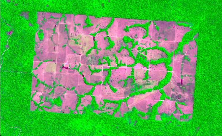
High resolution imagery from a Sentinel satellite of deforestation around Nova Bandeirantes, Mato Grosso, Brazil. Image: Shutterstock
Tips to Get the Most from Satellite Imagery
Use Different Spectral Bands
Spectral bands are different parts of the electromagnetic spectrum and cover specific wavelengths. (Here’s a handy introduction to different spectral bands.) Satellites capture all bands but the first view of satellite imagery is likely to be in natural color. Viewing the same set of images in other spectral bands can allow reporters to pick up different details. For example, using the near infrared band can show fire damage more clearly.
“The near infrared band is super helpful when you’re looking at burned areas. It’s usually used to look at vegetation and the health of vegetation. Things that show as bright red and pink are reflecting really hard in the near infrared,” said Farfour. “You can also look at crops and see deviations.”
Farfour cited as an example an infrared satellite image of Raqqa, Syria, in 2017, when the conflict against ISIS was escalating. The location of fires were clearly visible.
Don’t Make Assumptions and Beware of Cultural Biases
Farfour showed another series of satellite pictures taken of the Jebel Marra region of Sudan in April 2023. The near infrared images appeared to show areas of burned land, suggesting the damage was due to the recent fighting in the region. However, by looking at historic satellite imagery for the same location, Farfour concluded the same area burns every year, likely related to agriculture. “Don’t make assumptions just because you live in a place where they don’t burn the fields,” she warned.
Rotate Images When Using Google Earth Pro
“When you look at satellite imagery on Google Earth Pro desktop, buildings are sideways,” explained Farfour. “My brain cannot process imagery when buildings are sideways, I have no idea what’s going on. I’ve had situations where I’m trying to figure out if the cell phone towers are standing, or if someone came in and tried to eradicate them.”
This can be particularly problematic when Amnesty can’t access people on the ground to corroborate what they are seeing. Simply rotating the image using the dial on Google Earth Pro can help you better process what you are seeing.
Look for Patterns
When investigating the aviation fuel supply chain in Myanmar, detecting patterns was crucial for locating fuel depots. A list of locations on a company website helped narrow the search, but it was the repeat pattern of recently rebranded, green roofs and new safety features added to the depots and visible from the air that helped Farfour pinpoint their location.
Zoom Out
“Sometimes you’re drilled in so close to the image, if you zoom out, you actually get some perspective,” said Farfour. “You might find that there are hospitals nearby, but you’re so focused on this particular plane at the airport that you don’t see the hospital.”
-
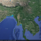
- গুগল আর্থের ডেস্কটপ সংস্করণে আপনি কোনো নির্দিষ্ট দেশ শনাক্ত করতে পারেন, এক্ষেত্রে, মিয়ানমার।
-
- রাজধানী বা কোনো নির্দিষ্ট অঞ্চল জুম করে দেখুন।
-
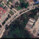
- আর রাস্তার ধারে বাড়ির ছাদ, অবকাঠামো ও যানবাহন দেখতে আরও খুঁটিয়ে দেখুন।
Satellite Imagery Analytical Tools
Farfour ran through a range of accessible tools for accessing and analyzing satellite imagery.
Google Earth Pro — desktop version. This easily accessible tool is useful because it gives a time series, allowing you to look at older imagery and compare it with more recent visuals. “This isn’t going to have updated imagery of the location that had an airstrike yesterday, but you will be able to get a base map of the area and understand what it looked like before and the buildings that were there,” explained Farfour.
Sentinel Hub EO Browser (free and pay options). Farfour suggested this as a great entry point for those who haven’t used satellite imagery before because of its range of free tools, information about what you are looking at, and tutorials.
One of Planet Labs’ premium products offers imagery in 3.7-meter (12 feet) resolution that covers the entire planet every single day. Large buildings, ships, and planes might be visible, but the real benefit is being able to compare imagery captured within a day. “For us, it means we can figure out when the airstrikes happened over a 24-hour period,” said Farfour. “Before this, you’d get an image maybe once every three months, unless it was like a high-value area. I use it as a kind of canary to tell me where to look closer with higher resolution imagery.”
The World Resources Institute forestry platform has some freely available imagery that may benefit environmental investigations.
SkyWatch sells imagery in smaller areas at a cheaper rate. “Typically, you have to order satellite imagery in a large chunk when all you want is one square kilometer,” explained Farfour.
Image Hunter sells imagery, and lets you see where people are trying to get images. This can help you identify an area of interest to investigate. “I will look at the map and figure out where people are trying to get images,” said Farfour. “Why are there certain places where people are trying to get images right now?”
Watch the IJF session with Micah Farfour at Perugia below.
Additional Resources
How to Expose Lies from the Skies Using Satellites and Drones
Interrogating China’s “Google Maps” to Investigate the Xinjiang Detention Centers
Reporter’s Guide to Investigating War Crimes: Open Source Research
 Laura Oliver is a freelance journalist based in the UK. She has written for the Guardian, BBC, Euronews, and others. She is a regular journalism trainer for the Thomson Foundation and Thomson Reuters Foundation and works as an audience strategy consultant for newsrooms. You can find her work here.
Satellite Images as Proof

Tipsheet: Latest Tools for Investigating with Telegram

Investigating Elections: Threat from AI Audio Deepfakes

Updated GIJN Databases (Poverty, Crime, Corruption, and Terrorism)
Experts Discuss Investigating Social Media Companies Like Facebook, Twitter, and TikTok
How to Reach Hard-to-Access Stories — and Audiences — with Audio

What Happens to Journalism When Social Media Sites Lose Their Relevance?
How a Team from Reuters Investigated Child Labor Abuses in the American South

This work is licensed under a Creative Commons Attribution-NoDerivatives 4.0 International License
Republish our articles for free, online or in print, under a Creative Commons license.
Republish this article
This work is licensed under a Creative Commons Attribution-NoDerivatives 4.0 International License
Read Next
News & Analysis Reporting Tools & Tips
Experts Discuss Investigating Social Media Companies Like Facebook, Twitter, and TikTok
Investigative journalists intending to cover social media and its societial effects must understand the intricacies of the companies that drive them, and think critically about novel angles of coverage.
News & Analysis Reporting Tools & Tips
How to Reach Hard-to-Access Stories — and Audiences — with Audio
At the International Journalism Festival in Perugia, veteran journalists from Africa and the Middle East discussed the power and intimacy of audio and podcast reporting and how it can enable reporters to better access hard-to-cover stories.
News & Analysis
What Happens to Journalism When Social Media Sites Lose Their Relevance?
A panel at the 2023 International Journalism Festival in Perugia explored the implications for journalism of Twitter “dying” and Facebook’s pivot away from news.
News & Analysis
How a Team from Reuters Investigated Child Labor Abuses in the American South
A Reuters investigation uncovering how large corporations use child labor for chicken processing and auto supply manufacturing was a finalist for the 2023 Goldsmith Prize for Investigative Reporting. Here the reporters give insights to other journalists who want to explore illegal labor practices in their coverage areas.